Closed-loop community systems · Central Appalachia

Arcology — a new model for affordable rural living.

Food, water, energy, and fertility, organized to close on site so a community sustains itself instead of importing its survival.

Pikeville, Kentucky USDA Zone 6a Pre-pilot
100 people per pilot unit ~425 kg N/yr recovered from urine ~75% of calories from the land — by design 0 synthetic inputs required
The problem

Rural communities pay a premium to import their own survival.

Across rural and post-industrial America, the basics are trucked in and piped out — and every one of those open loops carries capital out of the community. Each problem is treated separately, with a separate, expensive fix.

Food shipped in
Counties grow commodity crops for export while residents drive an hour to fresh produce. In rural areas, "low access" means more than ten miles to a supermarket.
Inputs bought in
Farms depend on synthetic fertilizer, fuel, and feed they don't control — costs that have grown more expensive and more volatile, where one disrupted supply chain can erase a season.
Infrastructure aging out
Costly municipal water and sewer systems built for populations that have since left, maintained on a shrinking tax base.
The insight

These aren’t separate problems requiring separate fixes. They’re the same problem — open loops — and they are cheaper to solve together than apart.

Water, nutrients, calories, and energy are flows. If you design a community so those flows close on site instead of leaving the system carrying value, the recurring cost of living there drops structurally. The enabling pieces — source separation, nutrient recovery, affordable solar, decentralized water, remote-work connectivity — each matured independently. No one had assembled them into a single community model. So we did: specified, costed, and published.

~75%
of daily calories from the land — by design
425 kg
nitrogen recovered per 100 residents / year
0
synthetic fertilizer inputs required
100
people served per pilot unit
The model · Four subsystems, one loop

Towers do nutrition. Land does calories. The loop does the fertilizer.

Each part is sized off the same per-100-people unit, so growth is replication, not redesign.

01 · Residences

The people — demand and source.

40 households (2.5/hh) ringed around the tower, uphill of the cascade. Rooftop rainwater catchment ≈ domestic demand. Source-separating fixtures send urine, solids, and greywater out on three separate pipes.

~4,600 m³/yrrainwater captured · ≈ domestic demand
02 · Core tower

The icon — greens, fish, eggs.

A daylit grow dome with rotating aeroponic cylinders, a trout RAS basin, and laying hens. The clean potable loop is firewalled from the nutrient side. LED silos take it from icon to volume when density needs to climb.

15,000 kg produce · 2,000 kg trout · 27,000 eggsper tower per year
03 · Land tier

The calories — staples on contour.

Concentric rings double as contour terraces. A Three Sisters guild plus storage apples, sorghum, chestnut, and hazelnut — grown in season, kept for winter in cellar and bin.

~75% of daily caloriesfrom the land tier
04 · Nutrient loop

The engine — nutrients come home.

A gravity cascade: struvite from urine, black soldier flies on solids, vermifilter, constructed wetland, duckweed lagoon. Returns to the land as fertilizer and feed.

~425 kg N · ~38 kg Precovered per 100 residents per year
The daylit grow dome: rotating cylinders, fish basin at the base, rainwater cap.
The icon

The dome is the image. The silos are the volume.

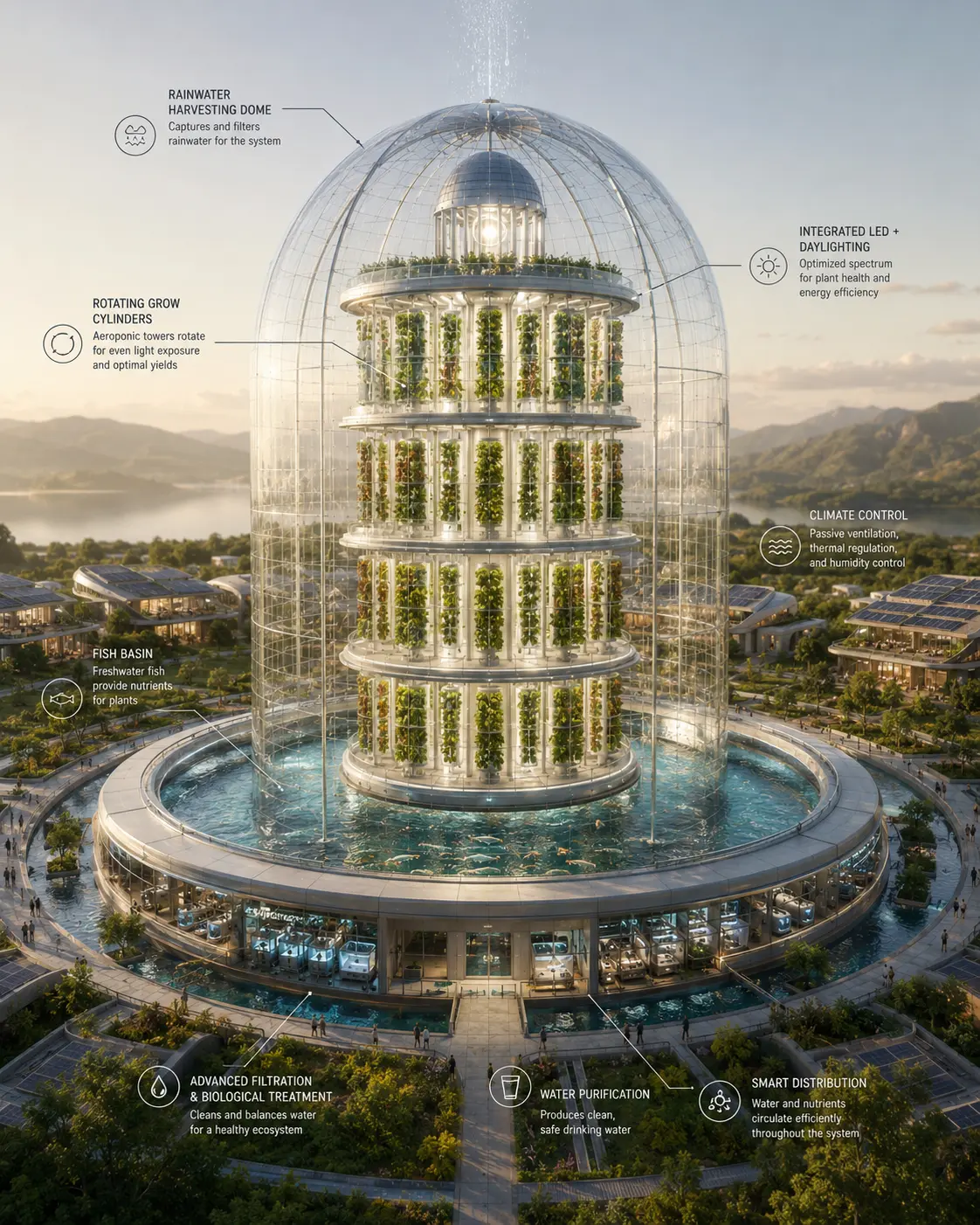
The daylit dome anchors the model: sun-driven, low opex, photogenic — capped at ~4–6 effective grow layers by self-shading. For density past that, the system shifts to corrugated LED silos: cheap envelope, 12–20 layers on a rotary that brings every cylinder to one ground-level harvest station. Both are sized off the same per-100-people unit.

  • Rainwater harvesting domeRoof captures and filters rainwater for the whole system. Potable in, never mixes with the cascade.
  • Rotating grow cylindersAeroponic towers rotate for even light. ~75 cylinders, four daylit tiers.
  • Trout RAS basin~100 m³ at the base. Cold-water; firewalled from the nutrient side. ~2,000 kg edible/yr.
  • Mechanical levelFiltration, biological treatment, UV. The clean loop’s brain.
The engine

We don’t produce waste. We produce fertilizer.

A community’s own outflows separate at the source and run downhill by gravity through five stages — returning nitrogen and phosphorus to the land, chemically identical to mined fertilizer. The clean side and the nutrient side never share an open surface.

Residences 40 households · 100 people ~4,600 m³/yr rainwater captured ≈ domestic demand Core Tower Clean potable + RAS loop 15,000 kg produce/yr 2,000 kg trout/yr 27,000 eggs/yr CLEANLINESS FIREWALL clean side ← | → nutrient side urine 50,000 L/yr solids + flush 5,000 kg/yr greywater Struvite reactor + N solution 425 kg N · 38 kg P /yr Black Soldier Fly 50–80% mass reduction ~40% protein larvae Vermifilter earthworms + microbes castings → staple beds Constructed wetland cattails, bulrush, root-zone Duckweed lagoon 10–20 t DM/ha/yr 30–45% protein feed Polishing pond clear water irrigation + flush* liquid fraction Staple terraces (Three Sisters + 4th sister, perennial agroforestry alley) contour rings below the residence belt ~75% of daily calories · ~10 acres per 100 residents struvite + N → beds vermicast → beds polished water BSF larvae → fish + poultry feed rainwater *Polished water is not drinking water — it serves irrigation and toilet flush only. Clean (potable + RAS) and nutrient flows never share an open surface. Recovered nutrients cross back only after full treatment. Every flow is a designed nutrient stream. Gravity does the work; pumps only return polished water uphill where needed.
The cleanliness firewall

The trout RAS and potable loop never share an open surface with the duck/duckweed/wetland side. Ducks live on the nutrient pond, not the fish basin. The dashed line in the diagram marks that separation.

Regulatory discipline by design

The clean routes — urine→struvite (sterile at source) and BSF→non-food-feed — are what the plumbing is built around. Every output that touches food is mapped before concrete is poured.

The model in numbers

Two levers, run independently.

Height drives people fed per acre. Cluster size drives cost per household. They’re separate variables on separate sliders — pull each one independently.

Lever AHeight → Density
Effective grow layers per tower footprint. Daylit caps at ~6; LED unlocks ~12–20 at an energy cost.
5
425 people/acre Sun-driven. No LED energy load.
Lever BCluster → Cost
Shared central plant, standardized fabrication, one big solar array. 20–40% off cost per household from pilot to district.
1
$50,000/household ~$2.0M total capex · pilot stage

Output — what this cluster produces

Pilot
100
people fed · 40 households · ~10 acres of staple terraces
Produce
15,000kg/yr
Trout
2,000kg/yr
Eggs
27,000/yr
Nitrogen recovered
425kg/yr
BSF feedstock
5,000kg/yr
Rainwater captured
4,600m³/yr

Tower share of daily calories: ~11%. The land tier supplies the balance — staples grown on the contour terraces below the residence ring. The calorie ladder section walks the math.

The calorie ladder

Tower delivers nutrition. Land delivers calories.

Daily target: 2,250 kcal/person. Stacked from the bottom: every protein and produce stream the tower supplies, then the staples that close the gap. The split follows what each tier grows efficiently — sun and soil for calorie density on the land, the tower’s volume for high-value nutrition.

0 kcal2,250 kcal/person/day
Greens5.5% Trout3.4% Chicken eggs2.4% Double trout3.4% Duck eggs4.4% Broiler3.3% Rabbit2.1% Land staples75.5%

Tower ceiling without staples ≈ 25%, maybe 30% with full animal-fat stacking. The remaining ~75% is land — corn, beans, potatoes, squash, sweet potato, sorghum, sunflower, nuts.

The story in one number
~75%

of the community’s daily calories come from the staple terraces. The tower carries diet quality; the land carries the calorie load. That ratio is the design.

Persistent gaps Cooking oil at volume (sunflower pressing narrows it) and high-protein bread wheat. Cornbread, rye, and buckwheat are the regionally honest answer.
The opportunity

A structural need — in a region already funding the solution.

The need is large and concentrated

The USDA estimates ~12.8% of the U.S. population lives in low-income, low-access tracts — roughly 19 million people in food deserts. Nine of the ten states with the greatest share are in the South, overlapping heavily with the communities Arcology serves. These are precisely the places with available land and a need for new economic models.

The capital is real and growing

Through its POWER Initiative alone, the Appalachian Regional Commission has invested $484.7M across 564 projects since 2015 — explicitly to fund agriculture, infrastructure, and entrepreneurship in coal-impacted communities. Its largest single package, $68.2M, came in 2024. Customers are already chasing exactly this funding.

19M
people in U.S. food deserts (USDA)
12.8%
of U.S. population in low-access tracts
$484.7M
ARC POWER investment since 2015
$68.2M
largest annual POWER package (2024)
The business model

Build to prove. License to scale. Engineer to sustain.

Build

Pilot communities

We develop pilot and demonstration communities that prove the model and generate development revenue. Capital-intensive, but the credibility engine for everything else.

Proves it
License

The model & standard

Developers, housing authorities, and municipalities adopt the model and design standard and fund their own builds. High-margin and capital-light — the licensee carries the capital.

Scales it
Engineer

Systems integration

We provide the design and systems-engineering to adapt the model to each site, monetizing the expertise directly between builds.

Sustains it

The license and engineering streams let the model travel on other people’s balance sheets — so we grow without owning every project’s capital stack.

Customer & competitive edge

A different business entirely.

Beachhead customer

The landowner-developer — an individual or small entity with rural acreage and access to capital, motivated by mission as much as margin. They have the two things a pilot needs: land and the means to build. The customer set then widens to institutional developers, housing authorities, and rural municipalities.

The moat is integration

The components are commodities anyone can buy. The hard part — what took a decade of systems-engineering — is assembling them into a single loop that closes affordably on a real site. Arcology serves rural communities where the value is lower cost of living, not premium urban produce. First credible, replicable standard wins the category.

Integration
accumulated systems know-how that deepens with each build
The standard
first replicable, costed model becomes the reference others build to
Founder + place
12 years embedded in the exact context this must prove out in
How it scales

Pilot, prove the loop. Cluster, share the plant. District, change the region.

Each phase is sized off the same per-100-resident unit, so growth is replication, not redesign — and cost per household falls 20–40% from pilot to district as infrastructure is shared.

PhaseTowersPeople / householdsWhat it addsCapex (planning)
Pilot 1 (partial loop) 100 / 40 One dome, prove the loop $1.5–2.5M
Small 1 (full loop) 100 / 40 Complete nutrient, poultry, water loops $2–3M
Cluster 5–8 + shared plant 500–800 / 200–320 Central water/nutrient/cold plant, shared solar, shared LED silos $8–15M
District 30–50 (5–8 clusters) 3,000–5,000 / 1,200–2,000 District staple greenhouses, reservoir, energy plant $50–120M
Rural economic impact

Rural America is not short on ingenuity. It is short on margin.

When the fixed cost of living falls structurally, households and communities gain surplus — capital and time that went to survival become available to build with. That freed capital is what people invest in their own ventures, equipment, and education. A community that sustains itself keeps its capital circulating locally instead of exporting it every month.

Households gain margin

Lower cost of living frees capital to invest in local enterprise and innovation.

A new rural industry

Each build spreads durable, place-based construction and operations jobs that can’t be offshored.

Value flows out as expertise

An Appalachian-born model exported to other rural regions — reversing a history of extraction.

The team

Operators who have built real things in this region.

PM
Payton May
Founder

Twelve years building ventures in central Appalachia, including BitSource — a software and data firm that retrained laid-off coal workers into software developers. Systems and integration background; architect of the Arcology model.

CJ
Charles Justice
Co-founder (prospective)

Civil and mining engineering experience across the energy industry. Brings the earthwork, site engineering, and heavy-infrastructure expertise the terracing, water, and cascade systems require.

LP
Lynn Parrish
Co-founder (prospective)

Background spanning the energy industry and land acquisition. Brings the land sourcing, partner relationships, and development capital pathways central to siting the first pilot.

Advised by research collaborators at the University of Pikeville on optimizing the system as an integrated whole.

Traction & goals

From a rigorous concept to a proven loop.

Where we are

The full system is specified, costed, and published, with a public build directive and a working economic calculator. A self-funded demonstration model is underway. We collaborate with the University of Pikeville on related research, and bring an existing network of municipal, healthcare, and institutional relationships built over twelve years.

True by October 2026

A working demonstration of the core loop will exist — instrumented, with real recovery-rate and water-quality data replacing estimates. A first pilot site will be identified in central Appalachia, with land access through business partners. The licensing framework will be structured and ready to activate the moment the demonstration validates the model.

Published
full system spec, build directive & calculator live
Self-funded
demonstration model underway, built capital-efficiently
12 yrs
regional operating history & institutional network
The ask

$100,000 builds the proof that unlocks everything downstream.

A full pilot is a ~$2M project — this raise doesn’t build a pilot, and we won’t claim it does. It builds a working demonstration of the core loop: the most novel, most doubted, most de-risking part of the model.

Build the proof

Materials, fabrication, instrumentation, and assays for a demonstration of the nutrient loop and grow tower — turning the most skeptical claim into measured recovery rates and water quality.

Turn proof into a business

Refine unit economics with real data, produce the licensable design standard, engage a first landowner-developer partner, and lay groundwork for the next raise.

A place that leads rather than lags — that exports a model instead of importing decline.

We have the land, the need, and increasingly the will. What we’ve lacked is a model. That is what this is.

Arcology · Pikeville, Kentucky · USDA Zone 6a